
 Español (es)
 English (en)
Contributing content
On this page
Add or Edit Facts
This section references the details of the form for adding or editing facts.
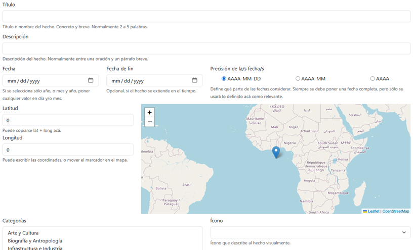
To add a new fact, access it from the application's main menu:

To edit a fact, you must log in to the project with your own account and enable the contributorMode setting, which activates the editing function when viewing facts (the small blue pencil icon to the left of the date).

Main Fields
Title
- Brief name or heading that identifies the fact.
- Required.
- We recommend keeping it short (less than 100 characters).
- Example:
"Foundation of Buenos Aires"
Description
- More detailed explanation of the fact.
- Required.
- May include historical context, significance, or consequences of the event.
- Example:
"The city of Buenos Aires was founded by Pedro de Mendoza in 1536, on the coast of the Río de la Plata."
Date
Date on which the fact occurred. A complete date including day, month, and year should always be provided. However, if the data is not exact, you can indicate that only the year, or the year and month should be considered, by setting the precision of the date(s).
If the fact spans over time, you can provide an end date to indicate the period during which it occurred.
Date
- Date of the fact.
- Required.
- Format:
dd/mm/yyyy. - Validations: Must be a valid date between -10000 and the current year.
- If the day or month is unknown, only the year or year and month can be used.
- Example:
02/02/1813
End Date
- Final date in case the fact has a duration (e.g., a historical period).
- Optional.
- If filled in, it must be a valid date equal to or later than the start date.
- Format:
dd/mm/yyyy. - Example:
09/02/1817(end of the Crossing of the Andes by the Liberating Army)
Precision of the Date(s)
- Level of detail or certainty regarding the date or dates associated with the fact.
- Required.
- Allows indicating whether the date has precision at the day, month, or year level.
- Available options:
YYYY-MM-DD: date defined by year, month, and day.YYYY-MM: date defined by year and month.YYYY: date defined by year.
- Example:
YYYY(if the fact occurred in the year 1823 but no more precise record exists)
Coordinates
Used to indicate the location where the fact occurred. There are several tools available to make entering this data easier. You can drag the marker on the map to the desired location, or first navigate to the place and then right-click to set it. Alternatively, you can directly enter the coordinates if they are already known.
You can copy both coordinates from Wikipedia when they are displayed (usually in the top-right corner). Similarly, if you're using a map service like Google Maps, you can right-click on the location to view its coordinates. Clicking on them copies the values to your clipboard. In both cases, if you paste the full coordinate value into the Latitude field, the system will automatically split them into the corresponding fields.
Latitude
- North-south coordinate of the fact.
- Required.
- Accepted formats: Decimal (
48.856944) or sexagesimal (48°51′25″ N). - Validations: Must be between
-90and90.
Longitude
- East-west coordinate of the fact.
- Required.
- Accepted formats: Decimal (
2.352222) or sexagesimal (2°21′12″ E). - Validations: Must be between
-180and180.
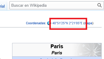
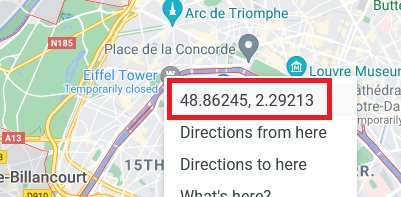
Automatic feature: When pasting full coordinates into the Latitude field, the system automatically splits them into both fields.
Categories
- Thematic classification of the fact (e.g.: History, Culture, Politics, etc.).
- Required: At least one category must be selected.
- Use the
Ctrlkey (Windows) orCmdkey (Mac) to select multiple categories.
Icon
- Representative image of the fact.
- Required.
- Relation: Depends on the selected category.
Image URL
- Web address of an illustrative image for the fact.
- Requirement: Optional, but recommended.
- The image must be free of copyright or in the public domain.
- Example:
https://upload.wikimedia.org/wikipedia/commons/thumb/0/0d/La_Plata_Catedral_2.jpg/800px-La_Plata_Catedral_2.jpg
General Validations
All of these rules are checked on the server, which is what decides whether a fact is stored. The form applies the main ones up front so you do not have to wait, but no contribution is accepted without passing the server's. When something fails, the affected field is marked and the reason is explained above the form.
| Field | Required | Validation |
|---|---|---|
| Title | ✅ Yes | Between 3 and 200 characters |
| Description | ✅ Yes | Between 10 and 5000 characters |
| Start date | ✅ Yes | Valid date between the year -10000 and the current year. Formats: YYYY, YYYY-MM or YYYY-MM-DD, prefixed with - for BC |
| End date | ❌ No | Same format and range. Cannot come before the start date |
| Date precision | ✅ Yes | One of the available options (millennium, century, decade, year, month, day) |
| Latitude | ✅ Yes | Number between -90 and 90 |
| Longitude | ✅ Yes | Number between -180 and 180 |
| Category(ies) | ✅ Yes | At least one, up to 64 |
| Icon | ✅ Yes | An icon must be selected |
| Element type | ✅ Yes | One of the three options offered |
| Content language | ✅ Yes | Spanish or English |
| Minimum and maximum zoom | ✅ Yes | Between 1 and 18, and the minimum cannot exceed the maximum |
| Radius | Only for a fact over an area | Whole number greater than 0 |
| Route points | Only for a fact with a route | At least 2 points, each with a valid latitude and longitude |
| Source (URL) | ❌ No | Must start with http:// or https:// |
| Images | ❌ No | Up to 20. Each one an https:// URL or a file name |
| Aliases | ❌ No | Up to 50, of up to 200 characters each |
| Multimedia content | ❌ No | Each entry needs a valid URL, a type (video, audio, document) and a language |
| Relationships | ❌ No | Each relationship needs a type and the identifier of the related fact |
License and Collaborative Use
- License: All added content is published under the CC0 license, meaning it is released into the public domain.
- Responsibility: Data may be reviewed, modified, or removed if considered inappropriate or incorrect.
- Log in: It is recommended to register and log in to collaborate.
- Authorship: A fact may pass through several hands. The server keeps the list of everyone who has edited it and adds each person the first time they save; nobody is lost or replaced by a later edit. That list is kept server-side and is not published: it never reaches the browser and never appears on the map. Contributing without logging in is recorded as anonymous.
- Automatic screening: Every save is checked by an automatic filter. It uses no artificial intelligence: they are fixed rules looking for insults, wholesale deletion, link spam and HTML tags. Content that is clearly inappropriate is refused and the reason is shown; anything doubtful is saved and flagged for a person to look at. If a refusal looks wrong, write to edumaps.ar@gmail.com.
- Simultaneous edits: If somebody else saved the same fact while it was being edited, the save stops and says so instead of silently replacing their work. Reload the page to see their changes before saving again.
- Previous versions: A copy of the content is kept before every edit. If an edit turns out to be wrong or malicious, the earlier version can be restored.
Return to Map
Once the form is completed and saved, the user returns to the main map where the fact appears with its location and details.
List of Previously Worked Facts
If other facts have been created or modified, they are displayed in a list that makes it easy to view them on the map, edit again, or copy their identifier (for example, to use as a step in a lesson).
Advanced Options
These options are available under a hidden section (Show advanced options) and are mainly intended for contributors with deeper technical knowledge.
Element Type
- Defines the shape the fact has in space: whether it happened at one point, covers an area, or is a route between places.
- Required.
- Options:
- A fact in one place: it happened at a specific point. The most common case.
- A fact over an area: it covers a zone, given as a radius around the point.
- A fact with a route: it joins several points, such as a journey or a campaign. The first point anchors the fact, so no separate latitude and longitude are asked for.
- Affects how the fact is drawn on the map and which other fields are asked for.
- The default value is A fact in one place.
Content Language
- The language the fact's title and description are written in.
- Required.
- It decides where the fact is stored and looked up: each language has its own space, and the fact will appear on the map when browsing in that language.
- It is independent of this screen's language, which is chosen in the top bar. You can contribute English content with a Spanish interface, and the other way round.
- Changing it while a fact is loaded re-reads that fact from the other language. Finding nothing there is not an error: it is a translation nobody has written yet.
- Example:
Spanish,English
Minimum Zoom
- Zoom level at which the fact begins to appear on the map.
- Range: 1 to 18 (with 1 being the global world view and 18 a highly detailed local view). Between 3 and 15 is recommended.
- Useful for showing facts only at certain levels of detail.
- Example:
5(visible when viewing the continent)
Maximum Zoom
- Zoom level at which the fact stops appearing on the map.
- Range: 1 to 18, and it cannot be lower than the minimum zoom.
- Used together with "Minimum Zoom" to control visibility range.
- Example:
12(no longer visible when zoomed in too closely to urban detail)
Radius
- The size of the area the fact covers, drawn as a circle around the point.
- Required only for a fact over an area; the other types do not ask for it.
- A whole number greater than 0. A radius of 50 is roughly 1 km.
Route Points
- The ordered list of points that make up the fact's line.
- Required only for a fact with a route, and at least 2 points are needed.
- They can be added by clicking on the map, dragged to move them, or typed in as coordinates.
- The first point anchors the fact: it is what places it and what opens its entry, so it should be the start of the route.
Source or Web Page with More Information (URL)
- Origin of the data. Bibliographic reference or URL where the information was obtained.
- Optional but recommended.
- Helps verify the accuracy of the content and facilitates future reviews.
- Example:
https://www.argentina.gob.ar/historia/fundacion-de-buenos-aires
Aliases or Additional Tags
- List of keywords related to the fact.
- Optional.
- Improves semantic search and filtering within the map.
- Example:
sanmartinian campaign
Multimedia Content
- List of multimedia files associated with the fact (audio, video, additional images, PDF documents, etc.).
- Optional.
- Each file must include:
- A valid URL.
- A type (audio, video, document).
- The language of the content.
Relationships
- List of other facts, people, or institutions related to this fact.
- Optional but valuable for the semantic network.
- Each relationship must include:
- ID of the related element.
- Type of relationship (e.g., cause, consequence, successor).
- Brief title or description of the relationship.
- Start year of the related fact (if applicable).
- End year of the related fact (if applicable).
Creating or editing a lesson
A lesson is a guided route across the map: a sequence of steps carrying the reader from one fact to the next, with a narrative of its own. Where a fact answers what happened, where and when, a lesson answers in what order it is worth looking at.
It is edited in the lesson form, which has two halves: the whole lesson's own details at the top, and the list of steps with its editor and a preview map below. Saving publishes the lesson — there is no intermediate draft state here (AI-generated drafts are worked on in a different editor).
Lesson details
- Title and description: required. This is what appears in the lesson catalogue and in the panel while the lesson is being followed.
- Date: required. Places the lesson on the timeline. It can be a year or a period, with the same precision as a fact (millennium, century, decade, year, month, day).
- Categories and icon: required, and they work exactly as they do on a fact: they decide the colour and the symbol the lesson shows on the map.
- Coordinates: optional. They mark the lesson as a point of its own, independent of its steps. Type them, or click on the preview map.
- Image and source (URL): optional, as on a fact.
Initial zoom
- The zoom level the map opens at when someone chooses this lesson.
- Optional. Left empty, the reader keeps the zoom they were already on.
- Range: 3 to 15. A new lesson starts with
5suggested, which shows a wide region and suits most. - Pick it for what the lesson covers: a lesson about a city reads better at a high number, one about an empire at a low one.
- A link that already carries the
zparameter takes priority over this value. The lesson's steps may also move the camera afterwards. - Not to be confused with Minimum zoom and Maximum zoom, which set the levels between which an element is visible on the map. The initial zoom hides nothing: it only says where the looking starts.
The steps
- The lesson is its list of steps, and the order matters: it is the order the reader travels in.
- Add step inserts one directly after the selected step, or at the end when none is selected.
- To reorder, drag a step by its handle, or use the up and down arrows on each row (which also work from the keyboard).
- Every step has its own title and description; that description is the narrative the reader follows.
- The preview map draws the whole route, numbered, and traces a line between steps that represent a journey.
Step types
- Text: narrative only. It has no place and no linked fact, and does not appear on the map.
- Fact: it rests on an already published fact, which supplies its location, image and icon. Give the fact's identifier, or search for it.
- Go to a fact: the same, but it also draws the journey from the previous step.
- Place and Go to a place: these use no existing fact. The place and its coordinates are given by hand, for moments that do not warrant a fact of their own.
A step's two years
- Year: the year the step sits at on the timeline. This is the one compared against the linked fact's range.
- End year: optional. The end of the period the step narrates, which may be wider than that single year. Left empty, it is published equal to the start year.
What is checked on save
- Title, description, date, categories and icon are required, and a lesson needs at least one step.
- A fact step needs a linked fact; a place step needs coordinates.
- A step's year must fall inside the linked fact's year range — otherwise that fact would not be visible at the moment the step mentions it.
- A step's end year cannot come before its start year.
- Every step needs its own title and description: a step with no text narrates nothing.
- All of this is checked on the server too: the form applies the rules up front so you do not have to wait, but the server is what decides.